‘Upwelling’: The Antarctic Melt
June 14, 2018 | Expert Insights
The high seas are getting even higher, and all that water is largely coming from a colossal Antarctic ice melt that has gotten much worse in recent years.
Background
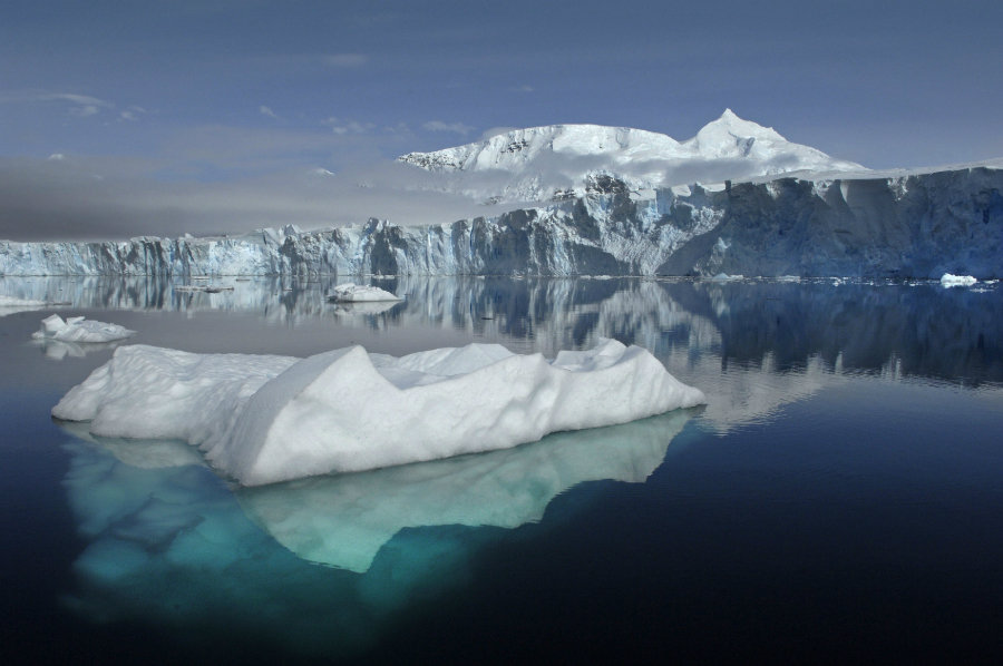
Antarctica is the southernmost continent on Earth. Surrounded by the Antarctic Ocean, it is larger than both Oceania and Europe. The Antarctic Ice Sheet is the largest single piece of ice on the planet. Its size ranges from approximately from 3 million square kilometers to 19 million square kilometers. Temperatures in the Antarctic range from -10° Celsius to -30° Celsius. Antarctica plays a major role in maintaining the Earth’s heat balance. The Antarctic Ice Sheet reflects solar radiation away from the Earth’s surface.
Climate change is an alteration in the statistical distribution of weather patterns when that change lasts for an extended period of time. Multiple studies published in peer-reviewed scientific journals show that 97% or more of actively publishing climate scientists agree that climate-warming trends over the past century are extremely likely due to human activities. Rising sea levels are one of the main consequences of climate change and global warming.
Analysis
A new climate assessment called the Ice Sheet Mass Balance Inter-Comparison Exercise (IMBIE) has found a startling rise in the sea level. NASA says ice losses from Antarctica have tripled since 2012, raising sea levels by 0.12 inch (3 millimeters), a faster rise than seen at any time in the past 25 years.
Now, for possibly the first time in 7,000 years, a phenomenon known as “upwelling” (the upward flow of warmer ocean water to the surface), is thought to have caused recent ice shelf collapse around the continent – and the glacial thinning associated with it.
Ice shelves floating on water are the oceanic extension of land glaciers and ice sheets, and the primary reason for ice loss. As these shelves break apart, the flow of continental ice held up behind them accelerates.
The ocean surrounding Antarctica is extremely cold, but water over 300m deep, Circumpolar Deep Water (CDW), is about 3⁰C above the melting point of ice. Normally, the very cold water above keeps this away from ice shelves. But in some areas, CDW is spilling onto the shallow Antarctic continental shelf, causing the ice to thin.
Ice shelf thinning has accelerated in recent decades, but the picture is not the same everywhere. While the east of the Antarctic has shown modest gains in ice thickness, the west has outstripped this with significant ice loss – up to 18% in vulnerable areas like the Amundsen and Bellingshausen Seas. The pattern of ice loss and other observations indicate that warmer water upwelling beneath these ice shelves is driving it.
Two teams, led by scientists from the British Antarctic Survey, have been working to tackle these precise questions by focusing on two vulnerable areas. One site is in Pine Island Bay, in the Amundsen Sea, and the other is in Marguerite Bay, in the Bellingshausen Sea.
The objective of the research is to monitor the extent of upwelling warm water onto the continental shelf over the past 10,000 years, in order to understand when this last occurred and what the impact was.
This involves collecting and sampling “cores” of sediment up to 10m long from the sea bed at a range of depths up to 900m. Obtaining suitable cores is particularly challenging in these remote locations, where glacial dynamics often disturb the sediment.
Much of the evidence for past oceanography comes from tiny shells of amoeboid organisms called foraminifera. Foraminifera’s are extremely valuable, as their shells are made of calcium carbonate precipitated from the ocean water in which they lived. Examining these shells allows us to reconstruct the chemistry of ocean water.
There were two geochemical tracers used for warm CDW in Pine Island Bay – the proportion of carbon isotopes, and the magnesium to calcium ratio controlled by water temperature. Both of these showed CDW was last on the inner shelf over 7,500 years ago.
In Marguerite Bay, shells of another plankton group called diatoms were also analyzed. These indicate past productivity and sea surface temperatures. They showed that CDW was persistently on the shelf here over 7,000 years ago, and more sporadically since then. Tellingly, the enhanced upwelling of warm CDW in both locations negatively impacted the local extent of ice.
Both studies suggest that the cause of the CDW upwelling before 7,000 years ago was a more southerly position of the southern hemisphere westerly winds (SHWW). These winds are thought to drive circulation of the warmer deep water. A recent shift in the position of the SHWW towards the poles could be the cause of greater CDW upwelling in Pine Island Bay since the 1940s.
This coincidence of timing with the onset of industrialization shows it is possible that human made greenhouse gasses, thought to cause atmospheric warming, are having an impact on the position of the winds, the increase in warm water reaching the surface, and ultimately the melting of more ice in the Antarctic.
Irrespective of the causes of past changes in SHWW positions, the link between winds and ocean upwelling is cause for concern, as future projected global warming may shift SHWW belts and promote further upwelling and melting.
Counterpoint
It is important to note that the melting glaciers and concomitant sea level rise occur very, very slowly by human standards. It is estimated that it would take between 200 and 900 years before the onset of rapid melting (greater than one millimeter a year) initiates the collapse of the West Antarctic Ice Sheet.
Assessment
Our assessment is that as the melting has already occurred, there is less in the way of topography or physical barrier to slow the glaciers accelerating flow into the sea. We feel that the glaciers may have passed the point of no return, and that the slow melt and the march of these glaciers to the sea cannot be stopped.


Comments